
S1TILING L1 products are based on Sentinel-1 Level-1 Ground Range Detected (GRD) products which are ortho-rectified on Sentinel-2 grid to promote joint use of both missions. These products are supplied […]
At the end of life of each satellite, CNES issues a call for ideas for short-term experiments taking place before de-orbiting the satellite. In 2012, CESBIO seized the opportunity to […]
The products of level 3A provide a monthly synthesis of surface reflectances from Theia’s L2A products. The synthesis is based on a weighted arithmetic mean of clear observations. The data […]
At the end of life of each satellite, CNES issues a call for ideas for short-term experiments taking place before de-orbiting the satellite. Based on the success of SPOT4 (Take5), […]
The Spot World Heritage Service opened in June 2015 with the first dataset about France. Two large areas are covered, between 1986 and 2015 : Multispectral images* covering metropolitan France […]
The Spot World Heritage Service opened in June 2015 with the first dataset about France. Two large areas are covered, between 1986 and 2015 : Multispectral images* covering metropolitan France […]
At the end of life of each satellite, CNES issues a call for ideas for short-term experiments taking place before de-orbiting the satellite. Based on the success of SPOT4 (Take5), […]
The products of level 3A provide a monthly synthesis of surface reflectances from Theia’s L2A products. The synthesis is based on a weighted arithmetic mean of clear observations. The data […]
The Spot World Heritage Service opened in June 2015 with the first dataset about France. Two large areas are covered, between 1986 and 2015 : Multispectral images* covering metropolitan France […]
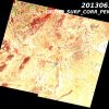
Le produit SWH 1A correspond au produit historique SPOT scène 1A au format DIMAP (GeoTIFF + métadonnées XML). Il s’agit du premier produit image avec une correction radiométrique qui égalise […]
The “continental vegetation and soils” biogeophysical products of Postel are spatialized variables derived from optical or micro-wave sensors measurements acquired over many years at regional to global scales. Postel Vegetation […]
The “radiation” biogeophysical products of Postel are spatialized variables derived from optical or micro-wave sensors measurements acquired over many years at regional to global scales. The Downwelling Longwave Radiation (W.m-2) […]
Variables biophysiques caractéristiques de la végétation : Le LAI et le fAPAR sont reconnues comme des ECVs (Essential Climate Variables) par le Global Climate Observing System – GCOS). Plus d’informations https://www.theia-land.fr/en/blog/product/vegetation-variables […]
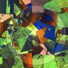
Main characteristics of the OSO Land Cover product : Production of national maps (mainland France)Nomenclature with 17 classes (2016, 2017) and 23 classes since 2018, spatial resolution between 10 m […]
The processing chain outputs rasters of the concentration of SPM estimated in the Bands B4 and B8. The concentration is given in mg/L. So a pixel value of 21.34 corresponds […]
Les produits du Centre Thématique Postel (2000-2008) au sein du Groupement d’Intérêt Public Medias-France sont principalement des produits à valeur ajoutée à l’échelle globale obtenus à partir de différents capteurs […]
Le produit SWH 1A correspond au produit historique SPOT scène 1A au format DIMAP (GeoTIFF + métadonnées XML). Il s’agit du premier produit image avec une correction radiométrique qui égalise […]
This dataset provides high-precision measurements of surface displacements for the AFAR area. The data is generated using the FLATSIM processing chain, designed for consistent and systematic INSAR analysis at large […]
Les produits Postel bio-géophysiques « variables de rayonnement » sont des variables spatialisées issues de mesures de capteurs optique et micro-onde, de moyenne résolution spatiale, acquises sur plusieurs années aux […]
Les produits Postel bio-géophysiques « variables de rayonnement » sont des variables spatialisées issues de mesures de capteurs optique et micro-onde, de moyenne résolution spatiale, acquises sur plusieurs années aux […]
SPOT 5 stereoscopic survey of Polar Ice.Les objectifs du projet SPIRIT étaient de constituer une importante archive d’images Spot 5 HRS sur les glaces polaires et, pour certaines régions, de […]
Les produits du Centre Thématique Postel (2000-2008) au sein du Groupement d’Intérêt Public Medias-France sont principalement des produits à valeur ajoutée à l’échelle globale obtenus à partir de différents capteurs […]
Les produits Postel bio-géophysiques « cycle de l’eau » sont des variables spatialisées issues de mesures de capteurs optique et micro-onde, de moyenne résolution spatiale, acquises sur plusieurs années aux […]
Les produits Postel bio-géophysiques « cycle de l’eau » issus de Postel sont des variables spatialisées issues de mesures de capteurs optique et micro-onde, de moyenne résolution spatiale, acquises sur […]
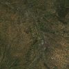
A land cover map associates to each pixel of the surface a labelling characterizing the surface (ex : deciduous forest, agriculture area, etc) following a predefined nomenclature. A commonly used […]
A land cover map associates to each pixel of the surface a labelling characterizing the surface (ex : deciduous forest, agriculture area, etc) following a predefined nomenclature. A commonly used […]
Les produits Postel bio-géophysiques « variables de rayonnement » sont des variables spatialisées issues de mesures de capteurs optique et micro-onde, de moyenne résolution spatiale, acquises sur plusieurs années aux […]
Data ortho-rectified surface reflectance after atmospheric correction, along with a mask of clouds and their shadows, as well as a mask of water and snow.The processing methods and the data […]
Main characteristics of the OSO Land Cover product : Production of national maps (mainland France) Nomenclature with 17 classes (2016, 2017) and 23 classes since 2018, spatial resolution between 10 […]
Les produits Postel bio-géophysiques « cycle de l’eau » sont des variables spatialisées issues de mesures de capteurs optique et micro-onde, de moyenne résolution spatiale, acquises sur plusieurs années aux […]
The Spot World Heritage Service opened in June 2015 with the first dataset about France. Two large areas are covered, between 1986 and 2015 : Multispectral images covering metropolitan France […]
Le produit SWH 1A correspond au produit historique SPOT scène 1A au format DIMAP (GeoTIFF + métadonnées XML). Il s’agit du premier produit image avec une correction radiométrique qui égalise […]
The L1C product contains 2 files : one with the metadata giving information on image acquisition (Instrument, date and time– projection and geographic coverage– Solar and viewing angles), and the […]
Data ortho-rectified surface reflectance after atmospheric correction, along with a mask of clouds and their shadows, as well as a mask of water and snow.The processing methods and the data […]
The Spot World Heritage Service opened in June 2015 with the first dataset about France. Two large areas are covered, between 1986 and 2015 : Multispectral images covering metropolitan France […]
The level 2A products correct the data for atmospheric effects along with a mask of clouds and their shadows, as well as a mask of water and snow.Landsat products are […]
The level 2A products correct the data for atmospheric effects and detect the clouds and their shadows. Data is processed by MAJA for THEIA land data center. Plus d’informations Sites […]
The products of level 3A provide a monthly synthesis of surface reflectances from Theia’s L2A products. The synthesis is based on a weighted arithmetic mean of clear observations. Plus d’informations […]
The level 2A products correct the data for atmospheric effects and detect the clouds and their shadows. Data is processed by MAJA for THEIA land data center. Plus d’informations Sites […]
At the end of life of each satellite, CNES issues a call for ideas for short-term experiments taking place before de-orbiting the satellite. In 2012, CESBIO seized the opportunity to […]
Les produits du Centre Thématique Postel (2000-2008) au sein du Groupement d’Intérêt Public Medias-France sont principalement des produits à valeur ajoutée à l’échelle globale obtenus à partir de différents capteurs […]
The L1C product contains 2 files : one with the metadata giving information on image acquisition (Instrument, date and time– projection and geographic coverage– Solar and viewing angles), and the […]
Les produits Postel bio-géophysiques « cycle de l’eau » sont des variables spatialisées issues de mesures de capteurs optique et micro-onde, de moyenne résolution spatiale, acquises sur plusieurs années aux […]
The main objective of the Sentinel-3 mission is to measuresea surface topography, sea and land surface temperature, and ocean and land surface colour with high accuracy and reliability to support […]
Sentinel-1 Level-1 products are the baseline products for the majority of users from which higher levels are derived. From data in each acquisition mode, the Instrument Processing Facility (IPF) generates […]

A Sentinel-2 Level-1C Collection 1 product provides orthorectified Top-Of-Atmosphere (TOA) reflectance, with sub-pixel multispectral and multitemporal registration accuracy. Technical quality masks, cloud and land/water are included in the product. The […]

Sentinel-1 Level-2 consists of geolocated geophysical products derived from Level-1. There is only one standard Level-2 product for wind, wave and currents applications – the Level-2 Ocean (OCN) product. The […]
The level 2A products correct the data for atmospheric effects and detect the clouds and their shadows.Data is processed by MAJA for THEIA land data center Plus d’informations https://www.cesbio.cnrs.fr/multitemp/sentinel-2/theias-sentinel-2-l2a-product-format/#English Caractéristiques […]