
CNES GRACE/-FO Level 2B 10-days Geoid Height Variations Grids


Products Description
Since 2002, the GRACE (Gravity Recovery and Climate Experiment; Tapley et al., 2004; Tapley et al., 2019) and GRACE-FO (GRACE Follow-On; Chen et al., 2022; Landerer et al., 2020) have been providing 10-days estimates of spatial and temporal variations in the Earth’s gravitational field. These variations can be converted into mass redistributions, including variations in water in the oceans, the hydrosphere, and the cryosphere, as well as deformations of the solid Earth related to glacial isostatic adjustment or major earthquakes.
Variations in geoid height represent fluctuations in the equipotential surface of the Earth’s gravitational field, caused by redistributions of mass from the Earth’s surface to its center, and expressed as vertical displacements (in millimeters) of this surface relative to its average state (Ditmar (2018) ; Wahr et al., 1998). They are calculated from the CNES GRACE/-FO Level 2A solutions, obtained by singular value decomposition (SVD) of the 10-days geopotential anomalies available here, and expressed as deviations from a fixed reference field.
The Stokes coefficients derived from these solutions are then converted into geoid height anomalies and projected onto the WGS84 ellipsoid using the locally spherical approximation (Equation 27, Ditmar (2018)), which is implemented in the LENAPY Python package. The official LENAPY documentation is available at this link, and its mathematical foundations are detailed here. No filters are applied, as the solution is stabilized by truncated SVD (Lemoine et al., 2026).
Files description
The Level 2B grids are provided as ASCII files consisting of a header followed by three columns of 64,800 lines containing longitudes, latitudes, and equivalent water depth values, respectively.
These grids are generated from Level 2A SVD solutions, from degree 2 to degree 90. Degree 1 is excluded because the estimates from the inversion do not accurately reflect movements of the geocenter.
To convert the L2A solutions into water height anomaly grids, a static reference field is subtracted from the solutions. For the RL0005 solutions, the field removed is the CNES RL05 reference field. This average static field is an estimate close to the Earth’s gravity field in June 2009 (see here for more details). The grid values are given with an accuracy of 5 significant figures.
Solution Quality Metrics
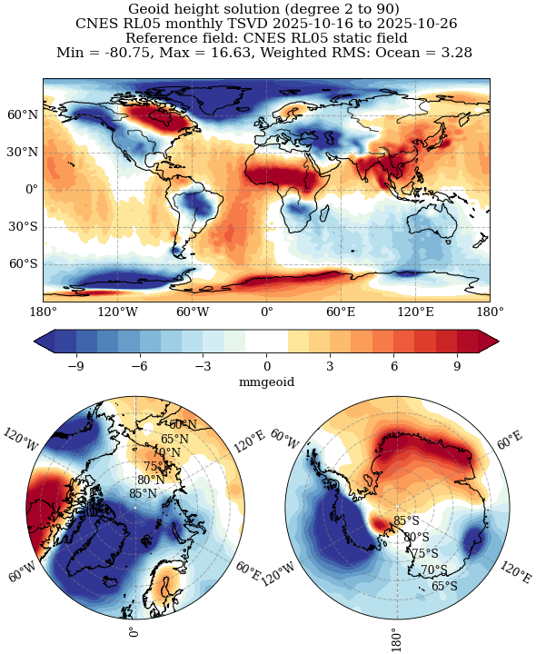
Geoid Height anomalies anomalies can be visualized as maps, as shown in the example in Figure 1.
Since the L2B solutions are derived from the L2A SVD solutions, no additional filtering is applied; however, vertical streaks corresponding to the anisotropic noise observed in the L2A solutions may remain visible.
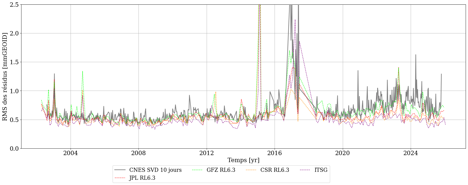
To quantify the noise level, a commonly used metric is the RMS of the time series after removing linear trends and annual cycles, calculated over an area considered to be quiet, such as the oceans. Since little signal is expected in these areas, a low RMS of the residuals indicates a solution with low noise. This analysis also allows for comparing the noise level between different solutions.
The noise in SVD solutions is particularly low compared to that of other solutions from other centers (JPL, GFZ, CSR, ITSG), which, although unconstrained, require DDK filtering to reduce noise.
Using the solutions
Users are invited to use the file upload tools as they see fit.
Dataset identifier
10.24400/170160/SAGSA_GFQ_GGH_SVD_10DAYS_RL0005
Characteristics
| Product type | Geoid height anomalies grids | |
| Format | ASCII files | |
| License | (CCBY) | |
| Start of production | GRACE: 01/04/2002 | GRACE-FO: 01/05/2018 | |
| End of production | GRACE: 01/05/2017 | GRACE-FO: Still producing | |
| Coverage | -180° – 180° ; -90° – 90° | |
| Coverage type | Global | |
| Spatial resolution | 1°x1° | |
| Time resolution | 10-days solutions | |
| Mission(s) | GRACE | GRACE-FO | |
| Instrument(s) / Captor(s) | Star Camera Assembly (SCA), Accelerometer (ACC), K-Band Ranging (KBR), GPS, Satellite Laser Ranging |
Citation
J.-M. Lemoine, S. Bourgogne, A. Boughanemi, J. Pfeffer, and E. Pellereau. Geoid height anomalies singular value decomposition 10-days, 2025e. URL https://geodes.cnes.fr/projects/l2b_cnes_sagsa_gfq_ggh_svd_10days/.
Bibliography
- (Chen et al., 2022; Ditmar, 2018; Landerer et al., 2020; Lemoine et al., 2026; Tapley et al., 2004, 2019; Wahr et al., 1998)
- Chen, J., Cazenave, A., Dahle, C., Llovel, W., Panet, I., Pfeffer, J., & Moreira, L. (2022). Applications and Challenges of GRACE and GRACE Follow-On Satellite Gravimetry. Surveys in Geophysics, 43(1), 305‑345. https://doi.org/10.1007/s10712-021-09685-x
- Ditmar, P. (2018). Conversion of time-varying Stokes coefficients into mass anomalies at the Earth’s surface considering the Earth’s oblateness. Journal of Geodesy, 92(12), 1401‑1412. https://doi.org/10.1007/s00190-018-1128-0
- Landerer, F. W., Flechtner, F. M., Save, H., Webb, F. H., Bandikova, T., Bertiger, W. I., Bettadpur, S. V., Byun, S. H., Dahle, C., Dobslaw, H., Fahnestock, E., Harvey, N., Kang, Z., Kruizinga, G. L. H., Loomis, B. D., McCullough, C., Murböck, M., Nagel, P., Paik, M., … Yuan, D.-N. (2020). Extending the Global Mass Change Data Record : GRACE Follow-On Instrument and Science Data Performance. Geophysical Research Letters, 47(12), e2020GL088306. https://doi.org/https://doi.org/10.1029/2020GL088306
- Lemoine, J.-M., Bourgogne, S., Gégout, P., Reinquin, F., Marty, J.-C., Mercier, F., Loyer, S., Bruinsma, S., & Balmino, G. (2026). 22 years of time-variable gravity field determination from GRACE and GRACE Follow-On : The CNES/GRGS RL05 solution. Journal of Geodesy, 100(2), 20. https://doi.org/10.1007/s00190-026-02040-1
- Tapley, B. D., Bettadpur, S., Watkins, M., & Reigber, C. (2004). The gravity recovery and climate experiment : Mission overview and early results. Geophysical Research Letters, 31(9), n/a-n/a. https://doi.org/10.1029/2004gl019920
- Tapley, B. D., Watkins, M. M., Flechtner, F., Reigber, C., Bettadpur, S., Rodell, M., Sasgen, I., Famiglietti, J. S., Landerer, F. W., Chambers, D. P., Reager, J. T., Gardner, A. S., Save, H., Ivins, E. R., Swenson, S. C., Boening, C., Dahle, C., Wiese, D. N., Dobslaw, H., … Velicogna, I. (2019). Contributions of GRACE to understanding climate change. Nature Climate Change, 9(5), 358‑369. https://doi.org/10.1038/s41558-019-0456-2
- Wahr, J., Molenaar, M., & Bryan, F. (1998). Time variability of the Earth’s gravity field : Hydrological and oceanic effects and their possible detection using GRACE. Journal of Geophysical Research: Solid Earth, 103(B12), 30205‑30229. https://doi.org/10.1029/98JB02844