
CNES SAGSA averaged Level 3 GRACE/-FO gravimetry solutions ensemble


GRACE/-FO SAGSA L3 gravimetry ensemble
The GRACE and GRACE-FO satellite missions continuously measure the Earth’s gravitational field and its evolution over time (Tapley et al., 2004 et Landerer et al., 2020, respectively) . With a spatial resolution of a few hundred kilometers and a temporal resolution that is generally monthly, these missions provide a unique view of global-scale mass redistribution, enhancing our understanding of water (Pfeffer et al., 2022) and energy (Meyssignac et al., 2019) cycles in a changing climate.
To accurately track variations in water mass in the oceans, hydrosphere, and cryosphere, Level 2 GRACE/-FO data must be corrected to:
- Remove non-water-related effects, such as Earth deformations resulting from deglaciation or earthquakes.
- Compensate for the limitations of satellites, which are not very sensitive—or not sensitive at all—to variations in gravity on a very large spatial scale.
- Reduce errors associated with anisotropic noise or signal leakage near coastlines (“leakage” effect).
The PANIS software applies these corrections and generates the SAGSA ensemble, based on the ensemble approach described by (Blazquez et al., 2018). This method combines various products and models using current best practices to produce robust surface water mass anomalies, while systematically estimating the uncertainties associated with the processing and post-processing choices for GRACE and GRACE-FO data.
Unlike the COST-G combined solution, which provides Level 2 geopotential products, SAGSA focuses on Level 3 surface water mass anomalies. The SAGSA dataset is thus an essential tool for research in hydrology, oceanography, and glaciology, providing both the water mass anomalies themselves and the uncertainties associated with their estimation.
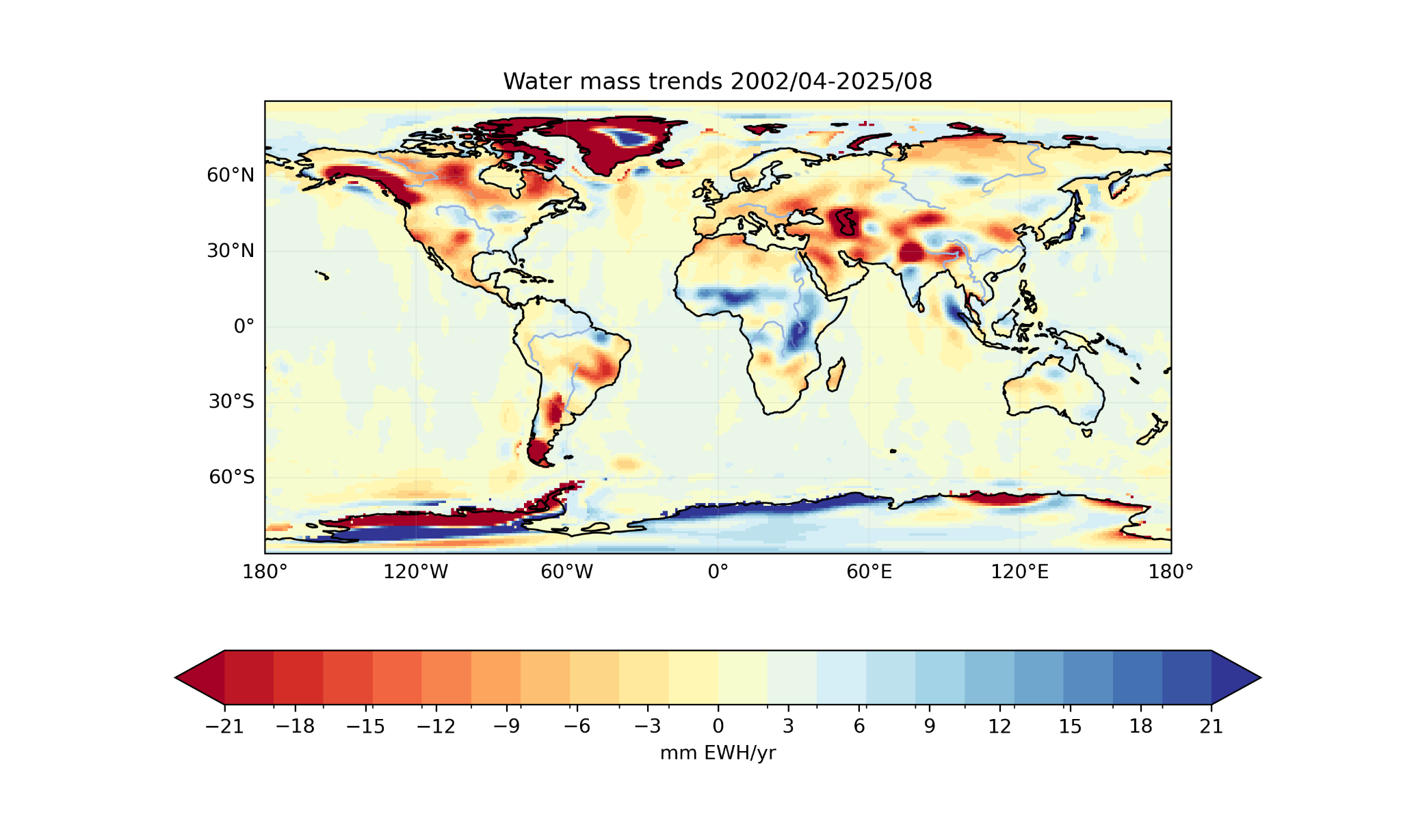
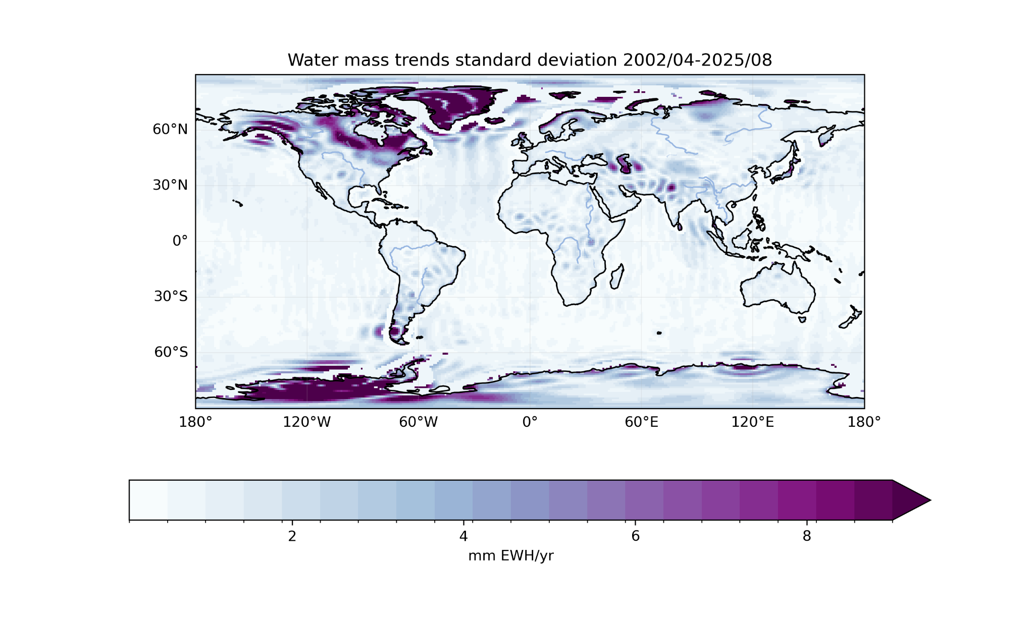
The trends in water body variations over the period 2002–2004 to 2025–2008 are shown in Figure 1 for the average of the Sigma ensemble, with their uncertainty estimated as one standard deviation.
Files description
The gravimetry dataset is available in NetCDF files and in zarr format.
The file contains the mean and standard deviation of the combined dataset.
For more details on the correction methods and the data used, users are invited to refer to the following page and the PANIS ATBD.
Using the solutions
To use the gravimetry dataset, users are encouraged to use the tools from the Python xarray library, which are best suited for handling NetCDF and .zarr files.
Dataset identifier
10.24400/170160/SAGSA_ENSEMBLE_1MONTH_PUBLIC_V2.1
Characteristics
| Product type | Monthly equivalent water height grids ensemble | |
| Format | NetCDF4 and .zarr files | |
| License | (CCBY) | |
| Start of production | GRACE: 01/04/2002 | GRACE-FO: 01/05/2018 | |
| End of production | GRACE: 01/05/2017 | GRACE-FO: Still producing | |
| Coverage | -180° – 180° ; -90° – 90° | |
| Coverage type | Global | |
| Spatial resolution | 1°x1° | |
| Time resolution | Monthly grids | |
| Mission(s) | GRACE | GRACE-FO | |
| Instrument(s) / Captor(s) | Star Camera Assembly (SCA), Accelerometer (ACC), K-Band Ranging (KBR), GPS, SLR |
Recommended references
- ATBD PANIS: Download link
- Blazquez et al., 2018
Version table for the complete ensemble
| Name | Version | Publication Date | Time Coverage | DOI | Product User Manual | How to Cite |
|---|---|---|---|---|---|---|
| L3_CNES_SAGSA_ENSEMBLE_1MONTH_public_V2.1 | 2.1 | 05/03/2026 | 2002-04 – 2025-08 | 10.24400/170160/SAGSA_ENSEMBLE_1MONTH_PUBLIC_V2.1 | In preparation (estimated publication date: second half of 2026) | A. Boughanemi, J. Pfeffer, A. Blazquez, H. Lecomte, N. Lalau, R. Fraudeau, and E. Pellereau. Sagsa graceensemble average, 2025b. URL https://geodes.cnes.fr/projects/l3_cnes_sagsa_ensemble_1month_public/. |
Bibliography
- Blazquez et al., 2018; Chen et al., 2022; Landerer et al., 2020; Meyssignac et al., 2019; Pfeffer et al., 2022; Tapley et al., 2004, 2019
- Blazquez, A., Meyssignac, B., Lemoine, J., Berthier, E., Ribes, A., & Cazenave, A. (2018). Exploring the uncertainty in GRACE estimates of the mass redistributions at the Earth surface : Implications for the global water and sea level budgets. Geophysical Journal International, 215(1), 415‑430. https://doi.org/10.1093/gji/ggy293
- Chen, J., Cazenave, A., Dahle, C., Llovel, W., Panet, I., Pfeffer, J., & Moreira, L. (2022). Applications and Challenges of GRACE and GRACE Follow-On Satellite Gravimetry. Surveys in Geophysics, 43(1), 305‑345. https://doi.org/10.1007/s10712-021-09685-x
- Landerer, F. W., Flechtner, F. M., Save, H., Webb, F. H., Bandikova, T., Bertiger, W. I., Bettadpur, S. V., Byun, S. H., Dahle, C., Dobslaw, H., Fahnestock, E., Harvey, N., Kang, Z., Kruizinga, G. L. H., Loomis, B. D., McCullough, C., Murböck, M., Nagel, P., Paik, M., … Yuan, D.-N. (2020). Extending the Global Mass Change Data Record : GRACE Follow-On Instrument and Science Data Performance. Geophysical Research Letters, 47(12), e2020GL088306. https://doi.org/https://doi.org/10.1029/2020GL088306
- Meyssignac, B., Boyer, T., Zhao, Z., Hakuba, M. Z., Landerer, F. W., Stammer, D., Köhl, A., Kato, S., L’Ecuyer, T., Ablain, M., Abraham, J. P., Blazquez, A., Cazenave, A., Church, J. A., Cowley, R., Cheng, L., Domingues, C. M., Giglio, D., Gouretski, V., … Zilberman, N. (2019). Measuring Global Ocean Heat Content to Estimate the Earth Energy Imbalance. Frontiers in Marine Science, 6(432). https://doi.org/10.3389/fmars.2019.00432
- Pfeffer, J., Cazenave, A., & Barnoud, A. (2022). Analysis of the interannual variability in satellite gravity solutions : Detection of climate modes fingerprints in water mass displacements across continents and oceans. Climate Dynamics, 58(3‑4), 1065‑1084. https://doi.org/10.1007/s00382-021-05953-z
- Tapley, B. D., Bettadpur, S., Watkins, M., & Reigber, C. (2004). The gravity recovery and climate experiment : Mission overview and early results. Geophysical Research Letters, 31(9), n/a-n/a. https://doi.org/10.1029/2004gl019920 Tapley, B. D., Watkins, M. M., Flechtner, F., Reigber, C., Bettadpur, S., Rodell, M., Sasgen, I., Famiglietti, J. S., Landerer, F. W., Chambers, D. P., Reager, J. T., Gardner, A. S., Save, H., Ivins, E. R., Swenson, S. C., Boening, C., Dahle, C., Wiese, D. N., Dobslaw, H., … Velicogna, I. (2019). Contributions of GRACE to understanding climate change. Nature Climate Change, 9(5), 358‑369. https://doi.org/10.1038/s41558-019-0456-2