
Sentinel-3 Level 1
The main objective of the Sentinel-3 mission is to measuresea surface topography, sea and land surface temperature, and ocean and land surface colour with high accuracy and reliability to support ocean forecasting systems, environmental monitoring and climate monitoring.
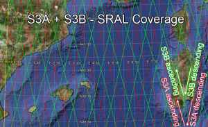
SRAL (Synthetic Aperture Radar Altimeter) is a redundant dual-frequency (C-band and Kuband) instrument for determining the two-way delay of the radar echo from the Earth’s surface with a precision better then a nanosecond. SRAL altimeter measurements are performed either in Low Resolution Mode (LRM) or in Synthetic Aperture Radar (SAR) mode. LRM mode is the conventional altimeter pulse limited mode with interleaved Kuband and C-band pulses, while SAR mode is the high along track resolution mode based on Synthetic Aperture Radar processing, made of Ku-band bursts, each of then being surrounded by two C-band pulses (for ionosphere delay correction) to be also able to operate over open ocean.
The GEODES platform is hosted in the CNES data centre in Toulouse, and, as a collaborative Ground Segment linked to the CDSE, distributes Level 1 data from Sentinel 3 from the entire temporal archive across all the geographic areas acquired.
Plus d’informations
Caractéristiques
| Type de jeu de données | Level 1 | |
| Format | https://sentiwiki.copernicus.eu/web/altimetry-products#AltimetryProducts-L1ProductcontentoverviewS3-Altimetry-Products-L1-Products | |
| Licence | https://sentinels.copernicus.eu/documents/247904/690755/Sentinel_Data_Legal_Notice | |
| Début de production | Fev-2016 | |
| Fin de production | N/A | |
| Emprise géographique | -180,-90,180,90 | |
| Type d’emprise | track | |
| Résolution spatiale | 300 m | |
| Résolution temporelle | According to S3 constellation | |
| Mission(s) | Sentinel-3 | |
| Instrument(s) / Capteur(s) | SRAL | |
| Métadonnées DataCite | N/A | |
| DOI | https://sentinels.copernicus.eu/web/sentinel/copernicus/sentinel-3 |