

Sentinel-2 Level 1C
A Sentinel-2 Level-1C Collection 1 product provides orthorectified Top-Of-Atmosphere (TOA) reflectance, with sub-pixel multispectral and multitemporal registration accuracy. Technical quality masks, cloud and land/water are included in the product.
The GEODES platform is hosted in the CNES data centre in Toulouse, and, as a collaborative Ground Segment linked to the CDSE, distributes Level 1C data from Sentinel 2 from the entire temporal archive across all the geographic areas acquired.
Plus d’informations
Caractéristiques
| Type de jeu de données | Level 1C | |
| Format | Sentinel-SAFE format, raster | |
| Licence | https://sentinels.copernicus.eu/documents/247904/690755/Sentinel_Data_Legal_Notice | |
| Début de production | Juil-2015 | |
| Fin de production | N/A | |
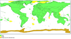
| Emprise géographique | -180,-56,180,84 | |
| Type d’emprise | 110×110 km tile in cartographic geometry (UTM/WGS84 projection) | |
| Résolution spatiale | 13 spectral bands – 4 bands at 10 m – 6 bands at 20 m – 3 bands at 60 m | |
| Résolution temporelle | According to S2 constellation,5 days | |
| Mission(s) | Sentinel-2 | |
| Instrument(s) / Capteur(s) | MSI | |
| Métadonnées DataCite | N/A | |
| DOI | https://doi.org/10.5270/S2_-742ikth |